Stalybridge Pennine Edge
Mixed area where the Pennines widen
Where?
Get there
-
Public Transport
 Bus/Train
-
Private Transport
Carparks
Public transport: Train/tram stations ‘Hadfield’, ‘Stalybridge’ and ‘Mossley’. Buses on major roads. Both need walk to edge. Private transport: access and parking everywhere.
Review
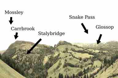
To the north, the Pennines narrow by half at the Oldham then Rochdale Pennine Edges. Stalybridge borough is at the north end of the Peak District, over 20 miles wide. Despite photos, is one uplift of land. Godly, Hattersley and Mottram in Longendale are largely estates notable only for their lead out of Greater Manchester to Hadfield (for some years, ‘Royston Vasey’) then Glossop (and the Snake Pass) and, northwards, the Woodhead Pass. The edge near Stalybridge is country parks and trails, in the Swineshaw reservoir valley. Can also walk over to Swallows Wood (known for birdwatching) and Tintwistle. Further north is Carrbrook and the tiny Harehills Valley, also country park. Finally, Mossley, where the Tame Valley is narrow, and the only walks are the edge and the river. No national landmarks or visit attractions, but quiet with odd features and fun views.