Oldham Pennine Edge
River valley with odd scenery and walks
Where?
Get there
-
Public Transport
 Bus/Tram
-
Private Transport
Carparks
Public transport: train stations at ‘Mossley’ and ‘Greenfield’—‘Greenfield’ is in valley, 3/4 mile from Greenfield village. Buses up the valley from Oldham/Ashton. Private transport: access everywhere. As for parking, usually, somewhere.
Review
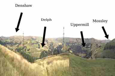
The east side of Oldham meets the South Pennines where the moors jut. The river Tame slices south–north, bucks the landscape. All the following places have a fish and chip shop, old pubs, stone buildings and graveyards. However, walks are what you get and, essentially, there are only three—the River Tame, the moor edge and, three miles east, the Pennine Way. Notable places: Mossley town (long history of split governance). Up a valley east is Greenfield and Dovestones, The small town Uppermill with the Saddleworth Museum & Art Gallery. In a valley north‐east from Uppermill is Diggle and the Standedge Tunnels. Then Delph—cartoon up‐downs and mostly preserved architecture. On high moor, Denshaw stands out: two pubs, no shop, moorland walks. You may also consider a walk to or from any of these places towards Oldham. Crazy‐back landscape, nowt there but pubs and walks—Manchester’s equivalent to Shropshire.