Middleton Pennine Edge
Open moorland with good walks
Where?
Get there
-
Public Transport
 Bus
Bus
-
Private Transport
Carparks
Public transport: Train/tram stations ‘Bury’ or ‘Rochdale’, but you’ll need long bus rides. Buses on all major roads. Private transport: access and parking everywhere.
Review
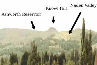
Walk any of these places, or between them—but read on. Ashworth Moor Reservoir—no facilities, no walk round. Good only as a waymark and for it’s sky‐meets‐water view. From Ashworth Moor Reservoir, passable walks east towards Ramsbottom in the Irwell Valley and down, via. Cheesden Valley, to Heywood. Owd Betts—dip with a road not low enough for a pass, rises to the oddity, Knowl Hill. Knowl Hill is not a map‐listed viewpoint, but can be seen halfway across Manchester, and is an icon for fellrunners and long‐distance walkers. Naden Valley—no facilities, walk on one side only, but patches of woodland, 1.5 mile of reservoir and a secret waterfall at the top. That said, beyond these visits, and the Manchester boundary, is Scout Moor. I’m not saying don’t go to Scout Moor, but it takes a mindset to enjoy the flat wastes of moor tops—for a simple day out, stick to the listed places. Also consider walking from here west towards Rochdale, where there are good transport connections.